
What is Cloudburst?
• A cloudburst is an extreme downpour in a short period of time. Cloudburst may be accompanied with hail and thunder.
• A cloudburst has a specific definition. According to the Indian Meteorological Department (IMD), an unexpected precipitation exceeding 100mm (or 10 cm) per hour over a geographical region of approximately 20 to 30 square km is a cloudburst.
• By this definition, 5 cm of rainfall in a half-hour period over the same area can be categorized as a cloudburst.
Rainfall vs Cloudburst:
• Rain is condensed water falling from a cloud which may or may not be intense, however a cloudburst in a sudden heavy downpour.
• Rain over 100mm per hour is categorised as a cloudburst. Heavy rainfall can be classified as a cloudburst only if it fits this criteria set by the IMD.
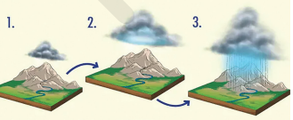
How and where does a Cloudburst Occur?
• Cloudbursts do occur at plains, however, mountainous regions are more prone to cloudbursts due to orography (the
geographical features of a mountain).
• A cloudburst occurs when warm air current from the ground or below the clouds rushes up and carries the falling raindrops up with it. As a result, new raindrops that are formed are heavier and denser.
• After a point, the raindrops become too heavy for the cloud and it falls down together in a short period over a small area, causing a cloudburst.
How common are Cloudbursts?
• During the monsoon months, cloudbursts are not uncommon events in India.
• Most of these happen in the Himalayan states where the local topology, wind systems, and temperature gradients between the lower and upper atmosphere facilitate the occurrence of such events.
Are Cloudburst Incidents Increasing?
• There is no long-term trend that suggests that cloudbursts are rising. However, incidents of extreme rainfall, as also
other extreme weather events, are increasing — not just in India but across the world.
• This kind of pattern, attributed to climate change, does suggest that cloudburst events might also be on the rise.
Impact:
• Short spells of very heavy rainfall over a small geographical area often trigger landslides and flash floods which can
cause widespread destruction downstream, especially in hilly regions.
What are some of the Worst Cloudbursts in India?
• Great Musi flood, 1908: On 26 September, 1908, Hyderabad’s surrounding areas witnessed a cloudburst. It was caused due to a cyclone in the Bay of Bengal. The city had recorded 153.2 mm rainfall on 27 September, 1908.
• Mumbai cloudburst, 2005: On 26 July, 2005, Mumbai received an astonishing 944 mm of rain in just 24 hours. It lead to a big chaos in the city.
• Uttarakhand cloudburst, 2013: In 2013, Uttarakhand’s Kedarnath received unprecedented heavy rainfall between 14 and 17 June. As per the state government data, the estimated toll was around 10,000, with over 3,000 persons missing .
Monitoring:
• The India Meteorological Department forecasts rainfall events well in advance, but it does not predict the quantum
of rainfall.
• Additionally, the forecasts are for a relatively large geographical area, usually a region, a state, a meteorological
sub-division, or at best a district. As they zoom in over smaller areas, the forecasts get more and more uncertain.
• Thus, it is very difficult to predict the cloudbursts due to its very small scale in space and time.
• To monitor the cloudburst, one needs dense radar network over the cloudburst-prone areas or a very high resolution weather forecasting models.